August 31, 2016 - TD#9
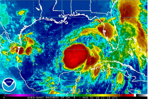
Tropical Depression #9 continues to spin away in the southern Gulf of Mexico. As of 700am, the center of the depression was located 400mi SSW of Apalachicola, FL. Movement was to the N at 2mph.
A Hurricane Watch is in effect for: Anclote River to Indian Pass, FL.
A Tropical Storm Warning is in effect for: Anclote River to the Walton/Bay County line in FL.
Forecasts continue to differ on possible strength and path. Some continue to keep the storm as a minimal tropical storm, while others have it ramping up to a low end Category 1 hurricane just before landfall.
If the storm keeps with its current forecast course, impacts to Alabama will be minimal. High surf and rip currents along the Alabama beaches are the only worries.

January 28, 2016 - One More Cool Day
COOL FRIDAY: One more fairly cool day upcoming on Friday, with highs in the 50s. Then, the stage is set for a fairly significant severe weather event early next week. One of the players will be introduced over the weekend, as warmer temps move in.
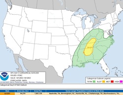
TUESDAY SEVERE?: As of now, the SPC Day 6 outlook has outlined a large portion of Alabama for a 15% chance of severe weather. This is rather rare, but not unheard of. The forecast based on models as of today is as follows: Strong to severe storms possible across North and Central Alabama Tuesday afternoon into Tuesday night. Storms will be capable of producing large hail, damaging winds, and a few tornadoes.
Timeframe looks to be between 2pm Tuesday and 2am Wednesday. Keep in mind this is still many days away, and things are likely to change. Make sure you have a severe weather plan in mind, and be ready to execute it should conditions warrant. Next update will be Saturday afternoon! -Scott
COOL FRIDAY: One more fairly cool day upcoming on Friday, with highs in the 50s. Then, the stage is set for a fairly significant severe weather event early next week. One of the players will be introduced over the weekend, as warmer temps move in.
TUESDAY SEVERE?: As of now, the SPC Day 6 outlook has outlined a large portion of Alabama for a 15% chance of severe weather. This is rather rare, but not unheard of. The forecast based on models as of today is as follows: Strong to severe storms possible across North and Central Alabama Tuesday afternoon into Tuesday night. Storms will be capable of producing large hail, damaging winds, and a few tornadoes.
Timeframe looks to be between 2pm Tuesday and 2am Wednesday. Keep in mind this is still many days away, and things are likely to change. Make sure you have a severe weather plan in mind, and be ready to execute it should conditions warrant. Next update will be Saturday afternoon! -Scott
January 24, 2016 - Sun!
After a week filled with clouds, rain and even some snow, it will be hard pressed to find a cloud in the sky across the state today. Temps will range from the upper 40s in the north, to the 50s across central and south Alabama.
After a week filled with clouds, rain and even some snow, it will be hard pressed to find a cloud in the sky across the state today. Temps will range from the upper 40s in the north, to the 50s across central and south Alabama.
July 14, 2015 - Severe Weather Possible?
A lot of questions coming in asking 'will we be dealing with severe weather on Tuesday?' As of right now, the answer is.....likely, mainly for areas NORTH of the I-20 corridor. Afternoon storms are possible, and could be strong to severe in isolated instances. Stronger storms possible later in the evening and during the early nighttime hours.
SETUP: The afternoon storms will pack a punch, like any summer thunderstorms. And some COULD briefly turn severe. But a widespread event is not expected. During the evening, upper-level winds will increase across the northern half of the state, allowing any storms that move in from the north, to retain their strength, and possibly form into an MCS (mesoscale convective system), producing damaging winds, upwards of 70-80mph.
TIMING: If afternoon storms fire, it should be in the 300-600pm range. Storms will linger into the late night hours.
IMPACTS: Damaging winds approaching 70-80mph in spots. Heavy rain that could cause flash flooding in areas. Dangerous cloud to ground lightning.
BE PREPARED: Residents across the northern half of Alabama should have a reliable source of weather information during the afternoon, and overnight Tuesday. Nothing to panic about, just be aware!
February 23, 2015 - Winter Weather Tuesday?
Sleet, freezing rain and snow possible across north and central Alabama overnight Monday, into early Tuesday morning. Travel will be impacted, with the biggest issues likely north of the I-20 corridor. Make sure you check travel conditions before leaving Tuesday morning. Some schools have already delayed start times, so check with your local system!
Next up....Wednesday. Our biggest shot of snow so far this year.
Next up....Wednesday. Our biggest shot of snow so far this year.

March 21, 2013 - SPC Day 3 Outlook. South Alabama.
Once again, the Storm Prediction Center has targeted portions of Alabama for the possibility of severe weather in their Day 3 (Saturday) outlook. The southern half of Alabama could see strong to severe thunderstorms. This is a developing situation, and could be shifted farther north if models come into agreement. Stay tuned.
Once again, the Storm Prediction Center has targeted portions of Alabama for the possibility of severe weather in their Day 3 (Saturday) outlook. The southern half of Alabama could see strong to severe thunderstorms. This is a developing situation, and could be shifted farther north if models come into agreement. Stay tuned.
March 16, 2013 - SPC Day 3 Outlook. Alabama Included.
The Storm Prediction Center has included the northern half of Alabama in their Day 3 severe weather outlook. The main threat looks to still be from straight line winds and large hail. Timeframe looks to be Monday afternoon into Monday night. This will be developing situation, so stay tuned!
The Storm Prediction Center has included the northern half of Alabama in their Day 3 severe weather outlook. The main threat looks to still be from straight line winds and large hail. Timeframe looks to be Monday afternoon into Monday night. This will be developing situation, so stay tuned!
March 15, 2013 - Strong/Severe Thunderstorms Monday?
The Storm Prediction Center has outlooked parts of Alabama, Mississippi, Georgia, Tennessee and Kentucky for the possibility of severe thunderstorms on Monday/Monday night.
Right now, the best bet for any severe weather looks to be over the northern 1/4 of Alabama, roughly north of Hwy 278. With the main timeframe looking to be late afternoon to near midnight.
Main risk with these storms will likely be from high winds and hail. But, with the unstable conditions that will be prevalent, an isolated spin up tornado can not be ruled out. -SM
March 2, 2013 - 'Flizzard' Across Alabama!
The weekend started off cold with flurries and light snow reports as far south as the Wetumpka/Montgomery areas. Highs on Saturday were mainly in the 30s and lower 40s. Saturday night will bring chilly temps ranging from near 20 in typically colder locations, to the upper 20s and lower 30s along the coast. Sunday will indeed be a 'Sun-Day'. Cold still, with highs in the 40s. Next shot at precip looks to be late Monday into Tuesday.
The weekend started off cold with flurries and light snow reports as far south as the Wetumpka/Montgomery areas. Highs on Saturday were mainly in the 30s and lower 40s. Saturday night will bring chilly temps ranging from near 20 in typically colder locations, to the upper 20s and lower 30s along the coast. Sunday will indeed be a 'Sun-Day'. Cold still, with highs in the 40s. Next shot at precip looks to be late Monday into Tuesday.
February 18, 2013 - Warmer Monday, Rain Moves In!
A sunny, but cold beginning of the week across Alabama today. Lowest temperature of the day was found in Etowah County, with a reading of 14 degrees, although most of the state averaged in the 20s.
Highs across the state today should reach the low 60s with clouds increasing ahead of gusty south winds. Rain moves in around midnight. Totals of 1/2" to 1" are possible. No severe weather is expected. Enjoy your day!
January 28, 2013 - Moderate Risk Issued
The Storm Prediction Center has placed portions of TN, AR, LA and MS under a moderate risk of severe weather on Tuesday.
The Storm Prediction Center has placed portions of TN, AR, LA and MS under a moderate risk of severe weather on Tuesday.
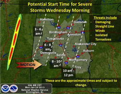
January 28, 2013 - Timing For Wednesday?
The timing for the potential severe weather event has been pushed into early morning Wednesday based on model data, that has the storm system slowing a bit. Right now, on best estimates, western counties should begin to feel the effects around 3am. The front will progress steadily across Alabama, exiting the eastern counties by 2pm.
This is a rapidly developing situation, and one to pay attention to.
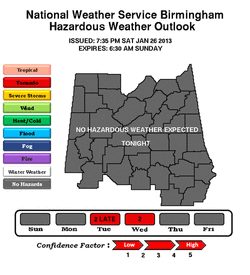
January 27, 2013 - Confidence Level From NWS BMX
The folks at the NWS in Birmingham think enough of the situation on Tuesday night/Wednesday, to warrant a level 2 confidence. Models are starting to come into agreement as to what may occur. At this time, a strong straight line wind event looks likely. With tornadic storms possible.
Stay weather aware for the next 48 hours across Alabama. Be prepared! -SM
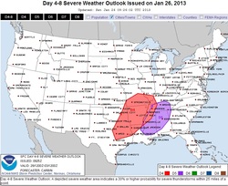
January 26, 2013 - SPC Outlook Targets Alabama
After the past 48 hours, and a little icing 'scare', we now look ahead to mid-week across Alabama. The SPC has outlooked portions of the state on their Day 4-8 convective maps. This doesn't mean a severe weather event is imminent. It just means that something is there, and on the table. Will have more on this as the models come into agreement within the next 48 hours!
Enjoy a partly cloudy, but cool Saturday and Sunday. -SM
